
Fire Behavior Case Studies
Ojo Feliz Wildfire
Return to main page of print version
Introduction
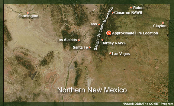
This case study examines a fire that occurred on April 17th, 2006 in north-central New Mexico. The fire burned in the transition zone between the east slopes of the Sangre de Cristo mountains and the high plains.
Review the Fuels, Topography, and Weather sections (below) to learn about the environmental conditions for this fire.
Then, continue to the Fire Behavior section to make a prediction about the types of fire behavior you would expect for the given conditions. Once you have made this prediction, go to the Limiting Factors section to answer a summary question about the limiting factors for this fire.
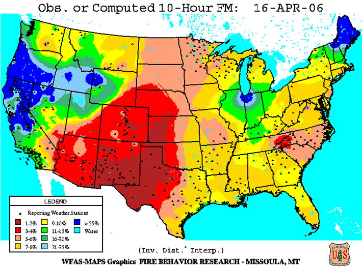
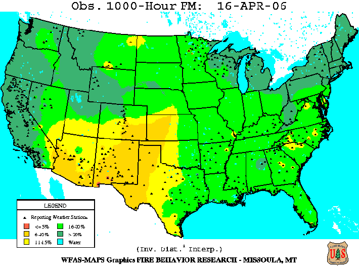
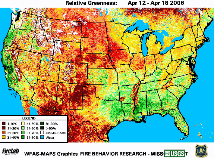
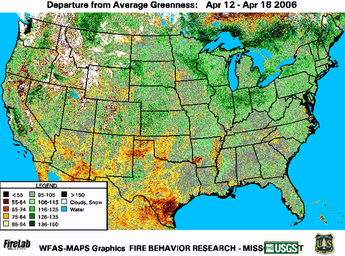
Fuels
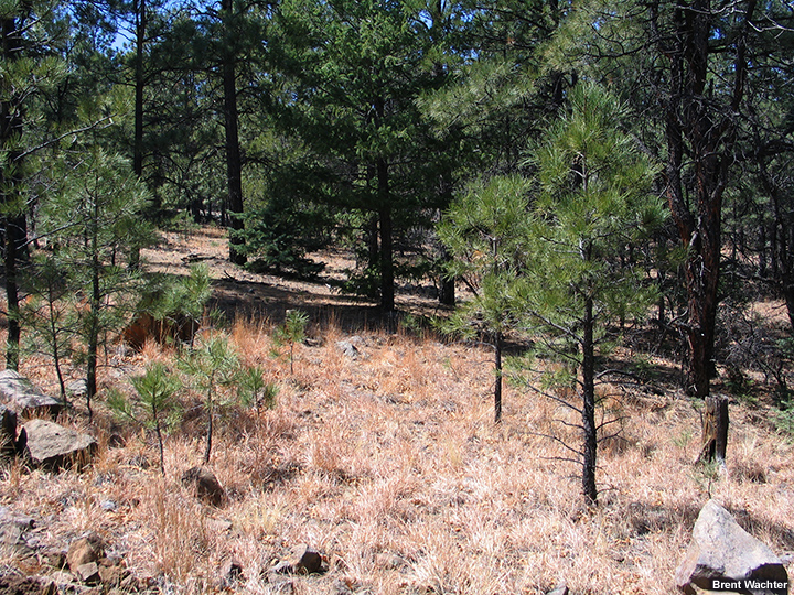
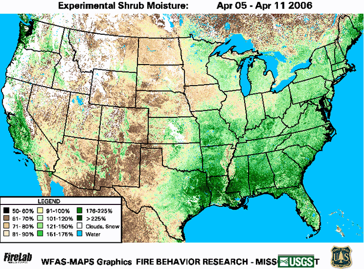
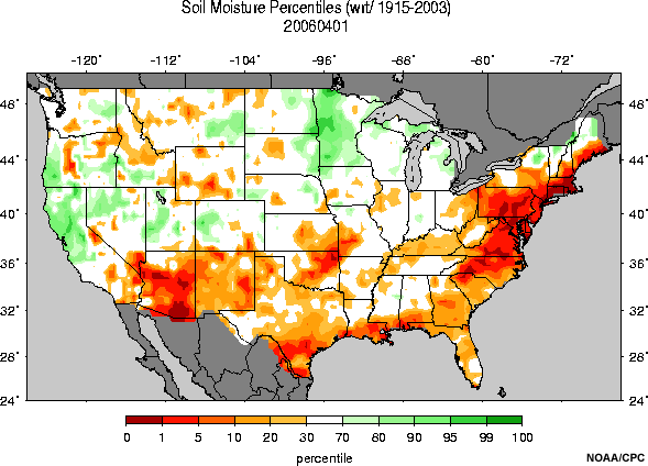
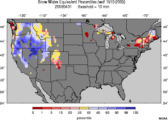
Fuels in the fire region include Ponderosa Pines intermixed with dormant oak brush and grasses.
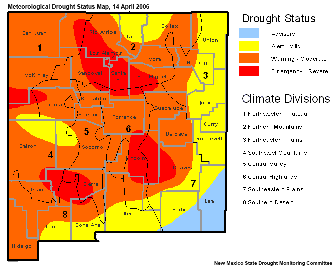
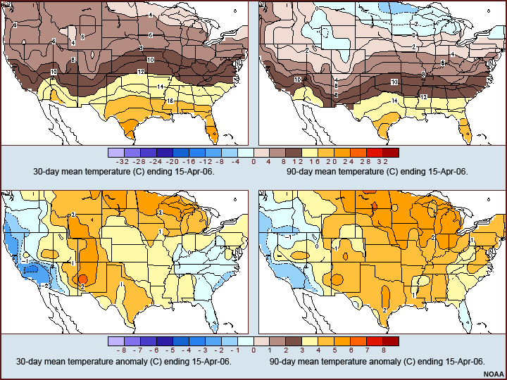
This fire occurred during the pre-greenup season for that region. Live fuels were dry and dead fuels very dry for this time of year, as the region emerged from winter with record low snowpack levels. Soil and fuel moistures were very low and the effects of a moderate drought were experienced throughout the region.
Examine the photos and data products below (you can click them to see enlarged versions) to form an understanding of the fuel situation for this fire. For more information about the data products presented, refer to the Assessing Fire Danger module in the Advanced Fire Weather Forecasters Course.


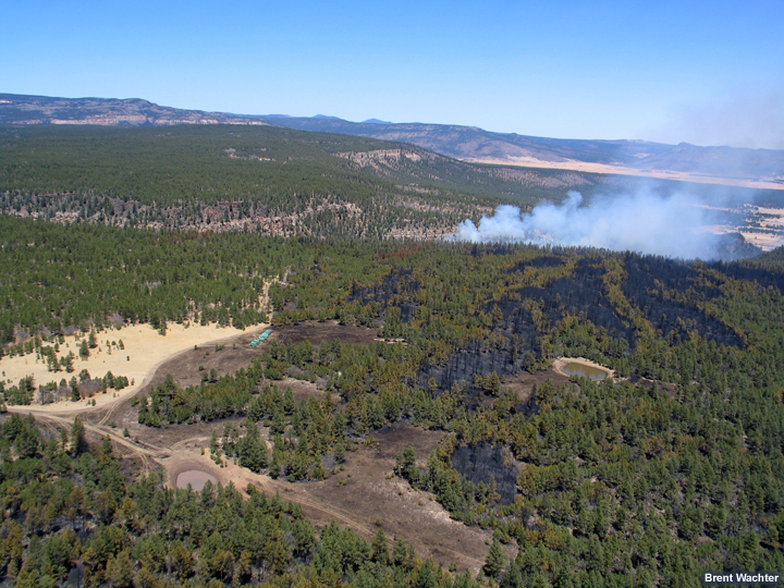
Topography
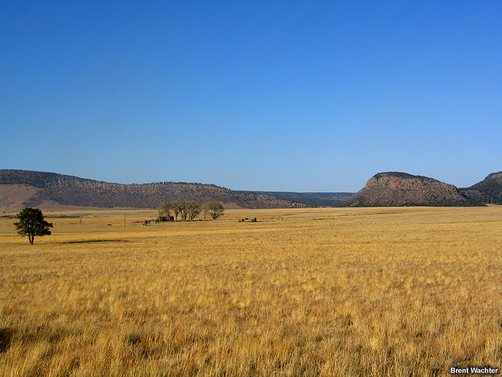
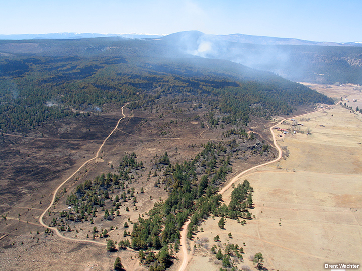
The Ojo Feliz fire occurred in a region situated to the lee of the north-south oriented Sangre de Cristo mountain range, with peaks over 13,000 ft tall. The fire area ranged in elevation between 7350-8300 ft.
The terrain may be characterized as a gently sloped plateau with one embedded steep canyon. The general slope was calculated at 25-30% for this fire.
Examine the photos below (you can click them to see enlarged versions) to form an understanding of the terrain configuration for this fire.
Weather
Weather conditions for this fire event were characterized by clear skies, very low humidities, above-normal temperatures, and strong surface winds.
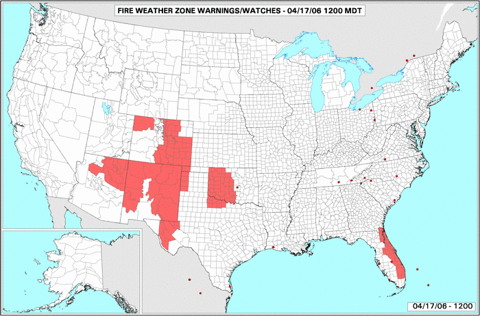
A Red Flag Warning was in effect for the region as a strong mid-level jet max in the base of an upper level trough pushed toward the area. Strong surface winds were forecast along with warm temperatures and minimum RH values of 5-10%.
Examine the data products below (you can click them to see enlarged versions) to form an understanding of the weather context for this fire. Data source locations are indicated on the basemap.

Text Products
The following text data are also available for your review.
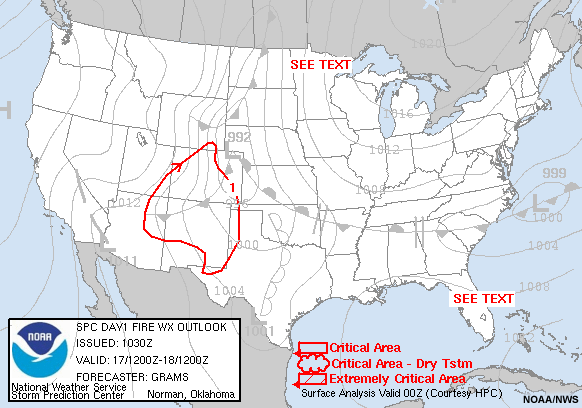
SPC Fire Weather Outlook
ZCZC SPCFWDDY1
ALLFNUS21 KWNS 170955
DAY 1 FIRE WEATHER OUTLOOK
NWS STORM PREDICTION CENTER NORMAN OK
0455 AM CDT MON APR 17 2006
VALID 171200Z - 181200Z
...CRITICAL FIRE WEATHER AREA FOR MUCH OF CO AND NM/NERN AZ/SERN UT/FAR SERN WY/FAR WRN TX AND OK PANHANDLES...
...SYNOPSIS... AN UPPER-LEVEL TROUGH FROM ERN WA TO NRN NV WILL MOVE EWD AND INDUCE LOW PRESSURE OVER ERN WY THIS AFTERNOON. A STRONG MID-LEVEL WIND SPEED MAX IN THE BASE OF THE TROUGH WILL SPREAD EAST INTO THE FOUR CORNERS REGION BY LATE AFTERNOON. DRY W/SW FLOW WILL INCREASE OUT AHEAD OF THIS SPEED MAX...
...CRITICAL FIRE WEATHER AREA 1 - MUCH OF CO AND NM/NERN AZ/SERN UT/FAR SERN WY/FAR WRN TX AND OK PANHANDLES...
PRIMARY CONDITIONS: STRONG WINDS / LOW RH / LONG-TERM DRYNESS
STRONG W/SW WINDS ALONG WITH VERY DRY AIR SHOULD PROVIDE WIDESPREAD CRITICAL FIRE WEATHER CONDITIONS THIS AFTERNOON. IN THE NERN PORTION OF THE OUTLOOK AREA...THE HIGHEST WINDS WILL OCCUR HERE OWING TO A STRONG MID-LEVEL SPEED MAX PUSHING EWD. AS LOW-LEVEL LAPSE RATES STEEPEN LATER THIS MORNING AND INTO THE AFTERNOON...MIXING OF THE STRONGER WINDS ALOFT WILL OCCUR. SUSTAINED SPEEDS OF 25 TO 35 MPH APPEAR LIKELY WITH HIGHER GUSTS AROUND 50 MPH...AS EVIDENCED BY RECENT SURFACE OBS ACROSS SRN NV INTO SWRN UT. AS TEMPERATURES WARM INTO THE 60S AND 70S IN LOWER ELEVATION AREAS...MIN RH VALUES WILL REACH 10 TO 15 PERCENT.
IN THE SWRN PORTION OF THE OUTLOOK AREA...WIND SPEEDS WILL BE MORE MARGINAL FOR CRITICAL CONDITIONS. HOWEVER...A VERY WARM AND DRY AIR MASS IS ALREADY IN PLACE ALONG WITH LONG-TERM DROUGHT CONDITIONS. WITH DOWNSLOPE CONDITIONS TEMPERATURES WILL WARM INTO THE 80S AND 90S WITH MIN RH VALUES OF 5 TO 10 PERCENT. SUSTAINED WIND SPEEDS SHOULD REACH CRITICAL VALUES AROUND 20 MPH LATE THIS AFTERNOON INTO THIS EVENING. POOR RH RECOVERY IS ALSO EXPECTED OVERNIGHT AS DOWNSLOPE W WINDS OF 15 TO 20 MPH CONTINUE...
..GRAMS.. 04/17/2006
NOAA
Weather Roundup
000
ASUS45 KABQ 171810
RWRNM
WEATHER ROUNDUP FOR NEW MEXICO
NATIONAL WEATHER SERVICE ALBUQUERQUE NM
1200 PM MDT MON APR 17 2006
NOTE: "FAIR" MEANS FEW OR NO CLOUDS BELOW 12,000 FEET AGL WITH NO
SIGNIFICANT WEATHER OR OBSTRUCTIONS TO VISION.
THIS PRODUCT IS RELEASED AS TWO VERSIONS. ONE VERSION NEAR
THE TOP OF THE HOUR CONTAINING PRELIMINARY DATA FROM ALBUQUERQUE
AND OTHER STATIONS. A FINAL VERSION WITH ADDITIONAL DATA IS
ISSUED ABOUT 10 MINUTES AFTER THE HOUR.
NMZ001-002-004-171900-
NORTHWEST PLATEAU/NORTHCENTRAL MOUNTAINS
CITY SKY/WX TMP DP RH WIND PRES REMARKS
FARMINGTON SUNNY 68 16 13 S16 29.90F
6HR MIN TEMP: 42; 6HR MAX TEMP: 68;
LOS ALAMOS FAIR 64 25 22 NE6 30.09S
SANTA FE SUNNY 67 18 15 W18G25 29.97F
6HR MIN TEMP: 34; 6HR MAX TEMP: 67;
TAOS MOSUNNY 61 16 17 SW10G16 30.00F
$$
NMZ005>007-171900-
NORTHEAST HIGHLANDS/NORTHEAST PLAINS
CITY SKY/WX TMP DP RH WIND PRES REMARKS
LAS VEGAS MOSUNNY 72 -6 4 W24 29.89S
6HR MIN TEMP: 38; 6HR MAX TEMP: 74;
RATON SUNNY 73 7 7 S12G23 29.81F
6HR MIN TEMP: 35; 6HR MAX TEMP: 73;
CLAYTON SUNNY 79 12 8 S16G24 29.76F
6HR MIN TEMP: 55; 6HR MAX TEMP: 79;
$$
000
ASUS45 KABQ 180110
RWRNM
WEATHER ROUNDUP FOR NEW MEXICO
NATIONAL WEATHER SERVICE ALBUQUERQUE NM
700 PM MDT MON APR 17 2006
NMZ001-002-004-180200-
NORTHWEST PLATEAU/NORTHCENTRAL MOUNTAINS
CITY SKY/WX TMP DP RH WIND PRES REMARKS
FARMINGTON CLEAR 70 11 10 W21G32 29.76S
LOS ALAMOS FAIR 68 14 12 SW18G32 29.97R
SANTA FE PTCLDY 72 -1 5 W22G28 29.82S
TAOS PTCLDY 66 10 11 W24G30 29.85R
$$
NMZ005>007-180200-
NORTHEAST HIGHLANDS/NORTHEAST PLAINS
CITY SKY/WX TMP DP RH WIND PRES REMARKS
LAS VEGAS PTCLDY 68 -8 4 W29 29.83F
RATON CLEAR 70 -2 5 SW23 29.74S
CLAYTON CLEAR 78 -6 4 SW15G25 29.64R
$$
NOAA
RAWS Data
Station                 GOES ID  Elev   Lat       Long
===========================================================
NM BARTLEY              32881572 8339   35:53:38  105:27:42
                                Dew                   Fuel   Peak  Bat  Fuel
                 Day/Time   Tmp Pt  Wind   Pcpn Rh    Temp   Wind  Volt Moist
====================================================================================
NM BARTLEY       18/1500Z   46/  5/2512/ 14.14 RH 18 FT 49/ 24G26 13.6 FM  4 SR 445
NM BARTLEY       18/1400Z   42/  9/2613/ 14.14 RH 25 FT 43/ 26G37 13.3 FM  4 SR 199
NM BARTLEY       18/1300Z   39/  9/2513/ 14.14 RH 29 FT 37/ 27G28 13.2 FM  4 SR  12
NM BARTLEY       18/1200Z   39/ 12/2611/ 14.14 RH 32 FT 36/ 25G22 13.2 FM  4 SR   0
NM BARTLEY       18/1100Z   41/ 13/2510/ 14.14 RH 31 FT 38/ 25G25 13.2 FM  4 SR   0
NM BARTLEY       18/1000Z   42/ 13/2513/ 14.14 RH 30 FT 40/ 22G28 13.2 FM  4 SR   0
NM BARTLEY       18/0900Z   44/ 15/2510/ 14.14 RH 30 FT 41/ 20G26 13.2 FM  4 SR   0
NM BARTLEY       18/0800Z   46/ 14/2512/ 14.14 RH 27 FT 43/ 26G24 13.2 FM  3 SR   0
NM BARTLEY       18/0700Z   48/ 13/2608/ 14.14 RH 24 FT 44/ 25G20 13.3 FM  3 SR   0
NM BARTLEY       18/0600Z   50/ 12/2509/ 14.14 RH 21 FT 46/ 23G22 13.3 FM  3 SR   0
NM BARTLEY       18/0500Z   52/  9/2508/ 14.14 RH 17 FT 48/ 24G17 13.3 FM  3 SR   0
NM BARTLEY       18/0400Z   54/  6/2607/ 14.14 RH 14 FT 49/ 27G16 13.4 FM  3 SR   0
NM BARTLEY       18/0300Z   55/  1/2705/ 14.14 RH 11 FT 49/ 29G17 13.4 FM  3 SR   0
NM BARTLEY       18/0200Z   57/ -4/2506/ 14.14 RH  8 FT 52/ 26G19 13.5 FM  3 SR   8
NM BARTLEY       18/0100Z   59/ -5/2408/ 14.14 RH  7 FT 56/ 24G21 13.6 FM  3 SR 115
NM BARTLEY       18/0000Z   63/ -2/2309/ 14.14 RH  7 FT 62/ 30G22 14.0 FM  3 SR 386
NM BARTLEY       17/2300Z   64/  2/2607/ 14.14 RH  8 FT 69/ 24G23 13.7 FM  3 SR 609
NM BARTLEY       17/2200Z   65/ -1/2211/ 14.14 RH  7 FT 74/ 24G24 13.7 FM  3 SR 805
NM BARTLEY       17/2100Z   65/  2/2411/ 14.14 RH  8 FT 77/ 26G24 13.7 FM  3 SR 934
NM BARTLEY       17/2000Z   65/  5/2509/ 14.14 RH  9 FT 79/ 22G29 13.8 FM  3 SR1001
NM BARTLEY       17/1900Z   65/ -1/2412/ 14.14 RH  7 FT 79/ 26G25 13.8 FM  3 SR1011
NM BARTLEY       17/1800Z   65/ -1/2513/ 14.14 RH  7 FT 77/ 25G28 13.8 FM  4 SR 957
NM BARTLEY       17/1700Z   64/ -5/2513/ 14.14 RH  6 FT 73/ 24G31 13.8 FM  4 SR 835
NM BARTLEY       17/1600Z   61/ -1/2611/ 14.14 RH  8 FT 67/ 25G27 13.9 FM  4 SR 663
NM BARTLEY       17/1500Z   57/ -1/2513/ 14.14 RH  9 FT 60/ 22G28 13.6 FM  4 SR 443
NM BARTLEY       17/1400Z   53/  4/2510/ 14.14 RH 13 FT 53/ 24G22 13.3 FM  4 SR 194
NM BARTLEY       17/1300Z   49/  3/2510/ 14.14 RH 15 FT 46/ 25G22 13.2 FM  4 SR  12
NM BARTLEY       17/1200Z   49/  5/2409/ 14.14 RH 16 FT 45/ 31G22 13.1 FM  4 SR   0
NM BARTLEY       17/1100Z   49/  5/2608/ 14.14 RH 16 FT 45/ 22G19 13.2 FM  4 SR   0
NM BARTLEY       17/1000Z   50/  9/2606/ 14.14 RH 19 FT 45/ 26G18 13.2 FM  4 SR   0
NM BARTLEY       17/0900Z   50/  9/3206/ 14.14 RH 19 FT 45/ 20G17 13.2 FM  4 SR   0
NM BARTLEY       17/0800Z   51/  8/2705/ 14.14 RH 17 FT 45/ 24G12 13.2 FM  4 SR   0
NM BARTLEY       17/0700Z   51/  5/2805/ 14.14 RH 15 FT 46/ 05G12 13.2 FM  4 SR   0
NM BARTLEY       17/0600Z   46/  7/3104/ 14.14 RH 20 FT 40/ 29G12 13.3 FM  4 SR   0
NM BARTLEY       17/0500Z   48/  5/3203/ 14.14 RH 17 FT 40/ 08G16 13.3 FM  4 SR   0
NM BARTLEY       17/0400Z   51/  6/2904/ 14.14 RH 16 FT 44/ 09G12 13.4 FM  4 SR   0

Station                 GOES ID  Elev   Lat       Long
===========================================================
NM CIMARRON             3333A53E 8744   36:36:21  105:07:13
                                Dew                   Fuel   Peak  Bat  Fuel
                 Day/Time   Tmp Pt  Wind   Pcpn Rh    Temp   Wind  Volt Moist
====================================================================================
NM CIMARRON      18/1505Z   42/  3/2212/ 45.71 RH 19 FT 46/ 19G31 14.9 FM  6 SR 461
NM CIMARRON      18/1405Z   40/  8/2211/ 45.71 RH 26 FT 40/ 20G27 14.7 FM  6 SR 202
NM CIMARRON      18/1305Z   36/ 13/2214/ 45.71 RH 38 FT 34/ 19G34 12.8 FM  6 SR  14
NM CIMARRON      18/1205Z   37/ 12/2310/ 45.71 RH 35 FT 35/ 22G27 12.7 FM  5 SR   0
NM CIMARRON      18/1105Z   38/ 14/2311/ 45.71 RH 37 FT 35/ 24G25 12.8 FM  6 SR   0
NM CIMARRON      18/1005Z   40/ 13/2310/ 45.71 RH 32 FT 38/ 26G27 12.8 FM  6 SR   0
NM CIMARRON      18/0905Z   42/ 12/2212/ 45.71 RH 29 FT 40/ 22G36 12.8 FM  6 SR   0
NM CIMARRON      18/0805Z   44/ 10/2113/ 45.71 RH 25 FT 42/ 19G32 12.8 FM  6 SR   0
NM CIMARRON      18/0705Z   46/  8/2215/ 45.71 RH 21 FT 44/ 22G37 12.8 FM  5 SR   0
NM CIMARRON      18/0605Z   48/  9/2213/ 45.71 RH 20 FT 46/ 17G31 12.9 FM  6 SR   0
NM CIMARRON      18/0505Z   50/  8/2210/ 45.71 RH 18 FT 47/ 19G33 12.9 FM  6 SR   0
NM CIMARRON      18/0405Z   52/  7/2211/ 45.71 RH 16 FT 49/ 19G25 13.0 FM  6 SR   0
NM CIMARRON      18/0305Z   53/  4/2209/ 45.71 RH 13 FT 50/ 23G21 13.1 FM  6 SR   0
NM CIMARRON      18/0205Z   55/ -3/2207/ 45.71 RH  9 FT 51/ 25G20 13.2 FM  6 SR   5
NM CIMARRON      18/0105Z   57/ -6/2008/ 45.71 RH  7 FT 54/ 20G25 13.4 FM  6 SR  57
NM CIMARRON      18/0005Z   59/ -8/2308/ 45.71 RH  6 FT 59/ 21G29 13.6 FM  6 SR 246
NM CIMARRON      17/2305Z   61/ -4/2409/ 45.71 RH  7 FT 64/ 21G22 13.9 FM  5 SR 569
NM CIMARRON      17/2205Z   63/ -9/2206/ 45.71 RH  5 FT 71/ 24G21 14.1 FM  6 SR 753
NM CIMARRON      17/2105Z   62/ -3/2108/ 45.71 RH  7 FT 72/ 23G22 14.3 FM  5 SR 878
NM CIMARRON      17/2005Z   62/  5/2308/ 45.71 RH 10 FT 73/ 19G18 14.5 FM  6 SR 954
NM CIMARRON      17/1905Z   61/  8/2109/ 45.71 RH 12 FT 72/ 20G26 14.7 FM  6 SR 972
NM CIMARRON      17/1805Z   62/  0/1907/ 45.71 RH  8 FT 68/ 21G24 14.1 FM  6 SR 929
NM CIMARRON      17/1705Z   59/  0/2010/ 45.71 RH  9 FT 60/ 22G22 14.2 FM  6 SR 820
NM CIMARRON      17/1605Z   57/  5/1107/ 45.71 RH 12 FT 63/ 16G18 14.9 FM  6 SR 656
NM CIMARRON      17/1505Z   53/  9/1505/ 45.71 RH 17 FT 57/ 22G13 14.5 FM  6 SR 453
NM CIMARRON      17/1405Z   49/ 11/0305/ 45.71 RH 21 FT 48/ 30G12 15.0 FM  6 SR 177
NM CIMARRON      17/1305Z   41/ 13/0504/ 45.71 RH 32 FT 32/ 13G13 12.8 FM  6 SR  14
NM CIMARRON      17/1205Z   32/ 12/2602/ 45.71 RH 42 FT 23/ 08G07 12.7 FM  6 SR   0
NM CIMARRON      17/1105Z   31/  9/2303/ 45.71 RH 39 FT 24/ 22G05 12.7 FM  6 SR   0
NM CIMARRON      17/1005Z   34/  8/2303/ 45.71 RH 33 FT 26/ 24G06 12.8 FM  6 SR   0
NM CIMARRON      17/0905Z   36/  8/2302/ 45.71 RH 31 FT 28/ 21G06 12.8 FM  6 SR   0
NM CIMARRON      17/0805Z   37/  7/2203/ 45.71 RH 28 FT 29/ 21G05 12.8 FM  6 SR   0
NM CIMARRON      17/0705Z   37/  6/2102/ 45.71 RH 27 FT 29/ 20G07 12.8 FM  6 SR   0
NM CIMARRON      17/0605Z   39/  7/2103/ 45.71 RH 26 FT 32/ 19G10 12.8 FM  6 SR   0
NM CIMARRON      17/0505Z   40/  5/2103/ 45.71 RH 23 FT 33/ 30G08 12.9 FM  6 SR   0
NM CIMARRON      17/0405Z   42/  7/2302/ 45.71 RH 23 FT 34/ 21G07 12.9 FM  6 SR   0
NOAA
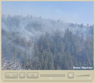
Video
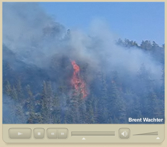
This video clip, recorded on the afternoon of April 17th, 2006, captures a sequence during which the winds began to strengthen at the surface, causing the fire to intensify. Notice how the smoke plume is vertical at the beginning of the video, but lays down along the slope of the canyon as the winds become stronger.
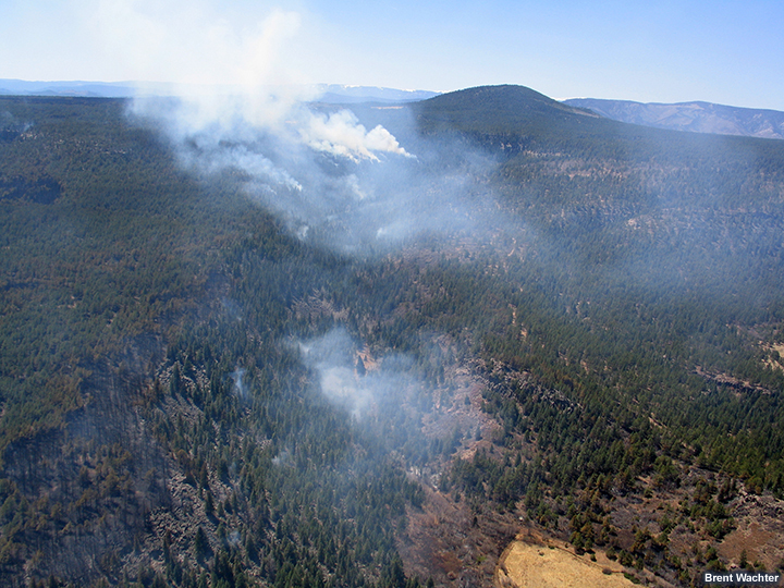
Fire Behavior
Question
What kind of fire behavior do you think resulted from the combination of fuels, topography, and weather conditions you have seen for this event?
- Smoldering, creeping surface fire
- Active surface fire with isolated torching and short-range spotting
- Extreme fire behavior with independent crown runs and long-range spotting
Feedback
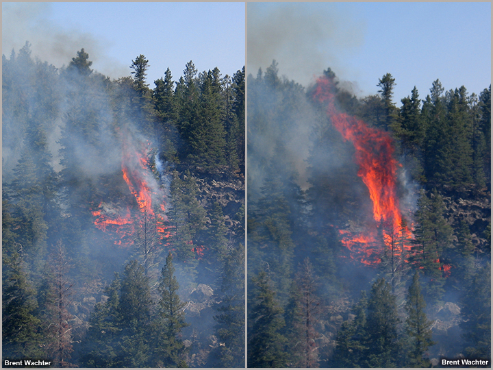
The correct answer is 2. An active surface fire resulted, with isolated torching and occasional group torching. There was also some short-range spotting (<100 meters).
Review the following photos and video clips to see what happened.
Videos
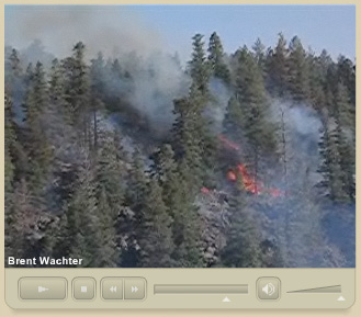
The following videos illustrate the types of fire behavior observed. The first video clip, recorded about 4:00 PM on April 17th, 2006, shows a small stand of trees torching as a group. Notice that the surrounding forest remains mostly intact as strong surface winds drive the plume horizontally along the canyon slope.
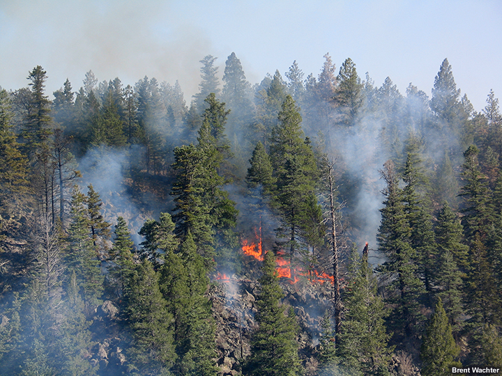
The second video clip, recorded about 5:00 PM on April 17th, 2006, shows the fire consuming surface fuels as it progresses upslope under strong winds. Notice that the fire does not seem to be entering the canopy, as most treetops remain green.
Limiting Factors
Question
Although there was some isolated torching, the Ojo Feliz fire never developed into a significant crown fire. Why? What limiting factors kept a crown fire from developing? (Choose all that apply from the list below.)
- Dead fuel moistures were too high
- Live fuel moistures were too high
- Fuel temperatures were too cool
- Fuel sources were too discontinuous
- There were not enough ladder fuel sources
- Insufficient heavy fuels (fuel sizes too fine)
- Topography was not steeply sloped
- Soil moistures levels were too high
- Air temperatures were not warm enough
- Relative humidities were too high
- Winds were too light
- Winds were not aligned with the terrain slope
- The atmosphere was too stable
Feedback
The correct answers are 3, 4, and 5. There were two main limiting factors for this case, fuel temperatures and fuel continuity. The Bartley RAWS had a peak fuel temperature of 79 degrees. During the peak fire season (June) fuel temperatures can exceed 110 degrees in this region. Higher fuel temperatures allow fuels to ignite and combust more easily. In addition, fuels were too discontinuous, both at the surface and in the treetops. The terrain was quite rocky in many areas, which prevents fuel loads from becoming heavy and tightly packed. Forest canopies were also fairly discontinuous because trees were not uniform in size. Thus, surface heating was insufficient to sustain significant crowning or group torching behaviors.
You have now completed this case study.