
Fire Behavior Case Studies
Rombo Mountain Wildfire
Return to main page of print version
Introduction
This case study examines a fire that occurred during mid-August, 2007 in the Bitterroot Mountains of southwestern Montana.
Review the Fuels, Topography, and Weather sections (below) to learn about the environmental conditions for this fire.
Then, continue to the Fire Behavior section to make a prediction about the types of fire behavior you would expect for the given conditions. Once you have made this prediction, go to the Limiting Factors section to answer a summary question about the limiting factors for this fire.
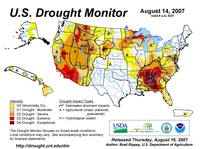
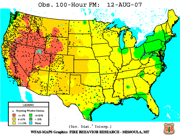
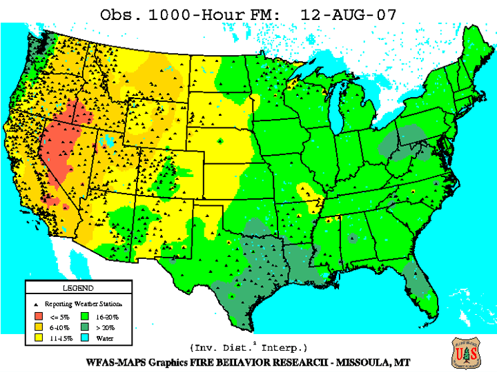
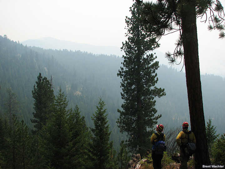
Fuels
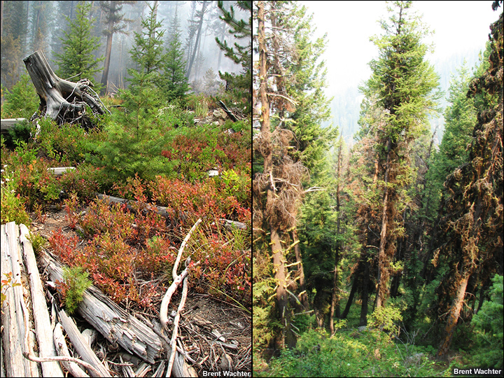
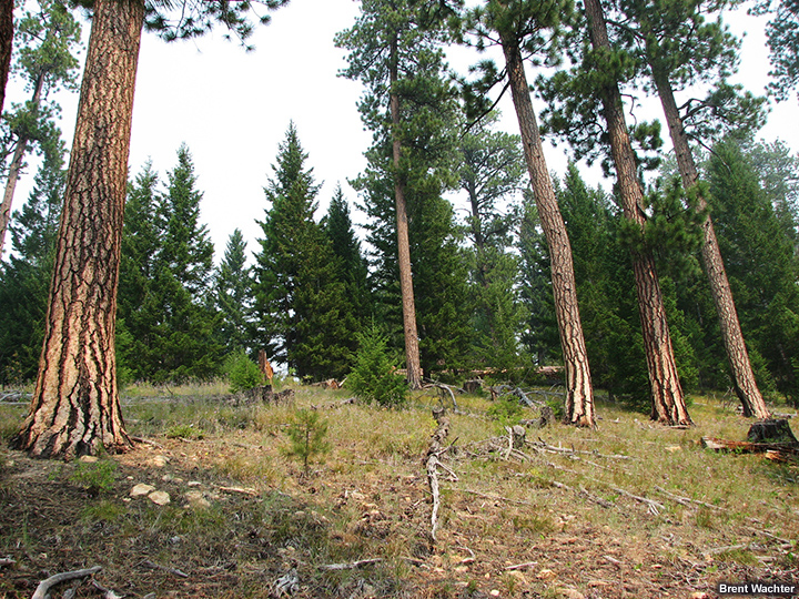
The fire burned in a fuel complex composed of douglas fir intermixed with sub-alpine fir, ponderosa pine, and lodgepole pine. The particular area of interest in the forest (for this case study) contained a mosaic of both previously burned areas and harvested tree plantation units. As a result, fuel arrangement was discontinuous both at the surface and in the canopies, although some scattered jackpots of heavy dead and down fuels were present.
Although record high Energy Release Component (ERC) values were measured for the area, herbaceous fuels were semi-cured, although they appeared relatively green under the shaded slopes.
Examine the photos and data products below (you can click them to see enlarged versions) to form an understanding of the fuel situation for this fire. For more information about the data products presented, refer to the Assessing Fire Danger module in the Advanced Fire Weather Forecasters Course.

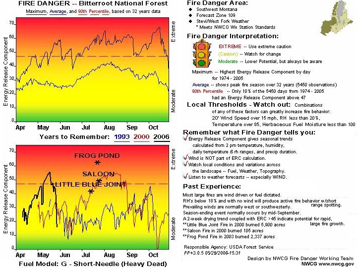
Click this graphic to see the full pocket card. Be sure to compare local weather thresholds on the card to RAWS observations given in the weather section below.
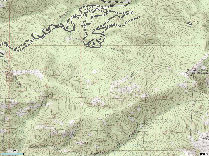
Topography
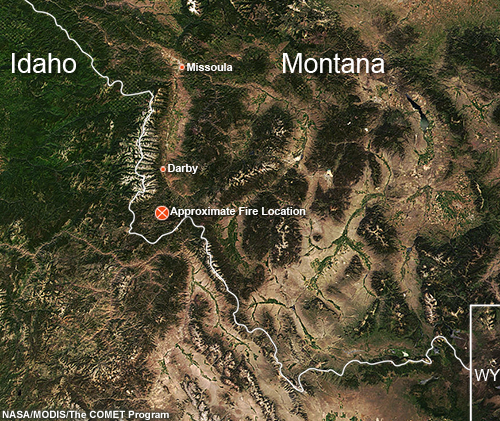
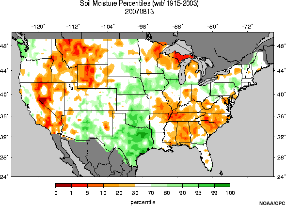
The Rombo Mountain wildfire occurred in the Bitterroot National Forest of extreme southwestern Montana. Rombo Mountain rises to over 8300 ft; some surrounding peaks in that part of the Bitterroot range reach nearly 9,000 ft. The Rombo Mountain wildfire burned forested ares of all aspects and ranged in altitude from 6300 to 8000 ft. Terrain was complex with some deep canyons and steep and highly varied slopes. Soil moisture levels were fairly dry.
Examine the photos below (you can click them to see enlarged versions) to form an understanding of the terrain configuration for this fire.
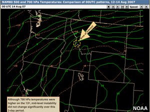
Weather
The weather on August 13 was characterized by low RH values and light upslope/up-canyon winds.
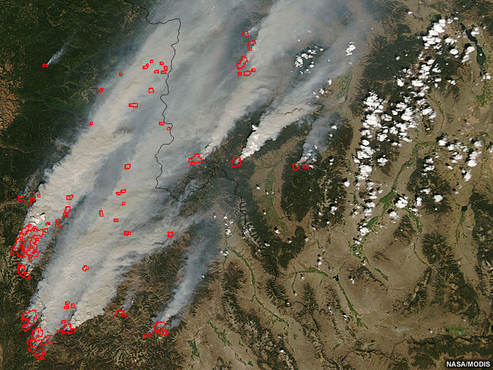
Meanwhile, large, intense wildfires were burning across the northern Rockies. Huge smoke plumes were observed spreading from central Idaho into western Montana.
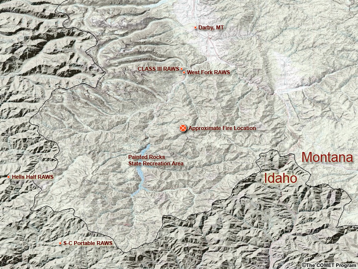
Examine the data products below (you can click them to see enlarged versions) to form an understanding of the weather context for this fire. Data source locations are indicated on the basemap.
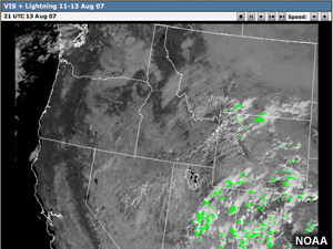
Numerous wildfires were burning across Idaho and Montana. The Rombo fire was active on 12 August.
Text Products
RAWS Data
Station                 GOES ID  Elev   Lat       Long
===========================================================
MT CLASS III 11-C  329144CC 5800   45:49:40  114:16:01
                                  Dew                   Fuel   Peak  Bat  Fuel
                   Day/Time   Tmp Pt  Wind   Pcpn Rh    Temp   Wind  Volt Moist
====================================================================================
MT CLASS III 11-C  14/0251Z   69/ 27/0402/  0.91 RH 21 FT 67/ 01G08 12.8 FM  4 SR  13
MT CLASS III 11-C  14/0151Z   71/ 28/0102/  0.91 RH 20 FT 70/ 30G08 12.9 FM  4 SR  48
MT CLASS III 11-C  14/0051Z   74/ 26/2804/  0.91 RH 17 FT 73/ 13G08 13.4 FM  4 SR 113
MT CLASS III 11-C  13/2351Z   77/ 27/1503/  0.91 RH 16 FT 78/ 05G10 13.7 FM  4 SR 217
MT CLASS III 11-C  13/2251Z   83/ 27/0603/  0.91 RH 13 FT 86/ 10G12 13.7 FM  4 SR 369
MT CLASS III 11-C  13/2151Z   86/ 27/2604/  0.91 RH 12 FT 92/ 09G17 13.7 FM  4 SR 569
MT CLASS III 11-C  13/2051Z   86/ 29/0704/  0.91 RH 13 FT 95/ 04G10 13.7 FM  5 SR 696
MT CLASS III 11-C  13/1951Z   84/ 31/0605/  0.91 RH 15 FT 97/ 09G10 13.7 FM  5 SR 737
MT CLASS III 11-C  13/1851Z   79/ 34/0704/  0.91 RH 20 FT 90/ 07G09 13.8 FM  5 SR 697
MT CLASS III 11-C  13/1751Z   72/ 31/0604/  0.91 RH 22 FT 84/ 07G08 13.8 FM  5 SR 630
MT CLASS III 11-C  13/1651Z   69/ 30/1902/  0.91 RH 23 FT 76/ 24G08 13.9 FM  5 SR 474
MT CLASS III 11-C  13/1551Z   57/ 32/2304/  0.91 RH 38 FT 60/ 20G12 13.9 FM  5 SR 298
MT CLASS III 11-C  13/1451Z   50/ 27/2106/  0.91 RH 40 FT 54/ 22G09 13.5 FM  5 SR 151
MT CLASS III 11-C  13/1351Z   50/ 27/2305/  0.91 RH 41 FT 50/ 22G10 12.7 FM  5 SR  39
MT CLASS III 11-C  13/1251Z   51/ 29/2306/  0.91 RH 42 FT 48/ 21G11 12.5 FM  5 SR   1
MT CLASS III 11-C  13/1051Z   52/ 26/2205/  0.91 RH 36 FT 50/ 22G14 12.5 FM  5 SR   0
MT CLASS III 11-C  13/0851Z   56/ 26/2308/  0.91 RH 31 FT 53/ 21G08 12.6 FM  4 SR   0
MT CLASS III 11-C  13/0751Z   59/ 27/2405/  0.91 RH 29 FT 55/ 23G08 12.6 FM  4 SR   0
MT CLASS III 11-C  13/0651Z   61/ 25/2305/  0.91 RH 25 FT 59/ 22G08 12.6 FM  4 SR   0
MT CLASS III 11-C  13/0551Z   64/ 25/2503/  0.91 RH 23 FT 60/ 03G08 12.7 FM  4 SR   0
MT CLASS III 11-C  13/0451Z   66/ 26/0601/  0.91 RH 22 FT 61/ 01G08 12.7 FM  4 SR   0
MT CLASS III 11-C  13/0351Z   68/ 23/1003/  0.91 RH 18 FT 66/ 28G08 12.7 FM  4 SR   0
MT CLASS III 11-C  13/0251Z   71/ 19/2904/  0.91 RH 14 FT 69/ 20G08 12.7 FM  4 SR   8
MT CLASS III 11-C  13/0151Z   74/ 22/2203/  0.91 RH 14 FT 70/ 17G14 12.8 FM  4 SR  21
MT CLASS III 11-C  13/0051Z   75/ 19/3304/  0.91 RH 12 FT 75/ 19G18 12.9 FM  4 SR  47
MT CLASS III 11-C  12/2351Z   81/ 17/1908/  0.91 RH  9 FT 79/ 25G27 13.4 FM  4 SR 137
MT CLASS III 11-C  12/2251Z   82/ 18/2307/  0.91 RH  9 FT 85/ 23G25 13.7 FM  4 SR 302
MT CLASS III 11-C  12/2151Z   83/ 21/2309/  0.91 RH 10 FT 88/ 24G28 13.7 FM  4 SR 461
MT CLASS III 11-C  12/2051Z   84/ 22/2410/  0.91 RH 10 FT 87/ 19G33 13.7 FM  5 SR 581
MT CLASS III 11-C  12/1951Z   85/ 20/2114/  0.91 RH  9 FT 92/ 18G32 13.7 FM  5 SR 773
MT CLASS III 11-C  12/1851Z   84/ 22/2118/  0.91 RH 10 FT 91/ 18G35 13.7 FM  5 SR 780
MT CLASS III 11-C  12/1751Z   80/ 25/1606/  0.91 RH 13 FT 89/ 20G15 13.8 FM  5 SR 674
MT CLASS III 11-C  12/1651Z   75/ 29/2209/  0.91 RH 18 FT 81/ 24G14 13.8 FM  6 SR 522
MT CLASS III 11-C  12/1551Z   60/ 33/2307/  0.91 RH 36 FT 66/ 20G14 13.9 FM  6 SR 362
NOAA/BLM
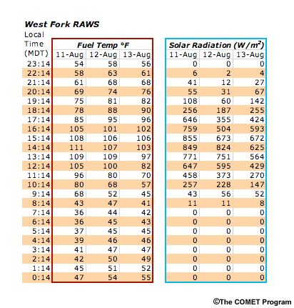
NOTE: The West Fork RAWS station (data below) corresponds to the Bitteroot N.F. pocket card shown in the fuels section above. Be sure to compare weather thresholds with the data given here.
Station                 GOES ID  Elev   Lat       Long
===========================================================
MT WEST FORK            326E0340 5200   45:49:05  114:15:47
                             Dew                   Fuel   Peak  Bat  Fuel
              Day/Time   Tmp Pt  Wind   Pcpn Rh    Temp   Wind  Volt Moist
====================================================================================
MT WEST FORK  14/0314Z   69/ 34/2702/  3.17 RH 27 FT 68/ 08G04 13.8 FM  4 SR  27
MT WEST FORK  14/0214Z   78/ 31/0604/  3.17 RH 18 FT 76/ 04G11 13.8 FM  3 SR  67
MT WEST FORK  14/0114Z   80/ 28/0607/  3.17 RH 15 FT 82/ 06G14 13.8 FM  3 SR 142
MT WEST FORK  14/0014Z   83/ 31/0705/  3.17 RH 15 FT 90/ 12G13 13.8 FM  3 SR 255
MT WEST FORK  13/2314Z   84/ 30/0507/  3.17 RH 14 FT 96/ 05G14 13.8 FM  3 SR 424
MT WEST FORK  13/2214Z   84/ 30/0808/  3.17 RH 14 FT102/ 05G16 13.8 FM  3 SR 593
MT WEST FORK  13/2114Z   84/ 34/1105/  3.17 RH 17 FT106/ 04G09 13.8 FM  4 SR 672
MT WEST FORK  13/2014Z   81/ 35/0604/  3.17 RH 19 FT103/ 05G07 13.8 FM  4 SR 625
MT WEST FORK  13/1914Z   76/ 36/1003/  3.17 RH 23 FT 97/ 11G05 13.8 FM  5 SR 564
MT WEST FORK  13/1814Z   65/ 32/1403/  3.17 RH 29 FT 82/ 17G05 13.8 FM  6 SR 429
MT WEST FORK  13/1714Z   59/ 34/1302/  3.17 RH 39 FT 70/ 34G09 13.8 FM  7 SR 270
MT WEST FORK  13/1614Z   52/ 31/2503/  3.17 RH 45 FT 57/ 32G07 13.8 FM  8 SR 147
MT WEST FORK  13/1514Z   45/ 33/2302/  3.17 RH 62 FT 45/ 22G06 13.8 FM  8 SR  52
MT WEST FORK  13/1414Z   43/ 32/2402/  3.17 RH 64 FT 41/ 22G06 13.8 FM  7 SR   8
MT WEST FORK  13/1314Z   44/ 30/2603/  3.17 RH 58 FT 42/ 22G06 13.8 FM  7 SR   0
MT WEST FORK  13/1114Z   47/ 32/2402/  3.17 RH 56 FT 45/ 23G07 13.8 FM  6 SR   0
MT WEST FORK  13/0814Z   51/ 30/2701/  3.17 RH 44 FT 49/ 27G04 13.8 FM  5 SR   0
MT WEST FORK  13/0714Z   54/ 28/3002/  3.17 RH 37 FT 52/ 28G04 13.8 FM  4 SR   0
MT WEST FORK  13/0614Z   56/ 29/2502/  3.17 RH 35 FT 55/ 34G04 13.8 FM  4 SR   0
MT WEST FORK  13/0514Z   61/ 29/2502/  3.17 RH 30 FT 58/ 35G03 13.8 FM  4 SR   0
MT WEST FORK  13/0414Z   65/ 27/3302/  3.17 RH 24 FT 63/ 25G04 13.8 FM  3 SR   2
MT WEST FORK  13/0314Z   70/ 28/3402/  3.17 RH 21 FT 68/ 34G05 13.8 FM  3 SR  12
MT WEST FORK  13/0214Z   76/ 27/0702/  3.17 RH 16 FT 74/ 06G05 13.8 FM  3 SR  31
MT WEST FORK  13/0114Z   82/ 22/0503/  3.17 RH 11 FT 81/ 15G13 13.8 FM  2 SR  60
MT WEST FORK  13/0014Z   86/ 18/2305/  3.17 RH  8 FT 88/ 22G21 13.8 FM  2 SR 187
MT WEST FORK  12/2314Z   88/ 19/2506/  3.17 RH  8 FT 95/ 24G18 13.8 FM  3 SR 355
MT WEST FORK  12/2214Z   89/ 20/2606/  3.17 RH  8 FT101/ 21G14 13.9 FM  3 SR 504
MT WEST FORK  12/2114Z   90/ 21/2606/  3.17 RH  8 FT106/ 22G16 13.9 FM  3 SR 673
MT WEST FORK  12/2014Z   89/ 20/1909/  3.17 RH  8 FT107/ 22G22 13.9 FM  3 SR 824
MT WEST FORK  12/1914Z   89/ 23/2106/  3.17 RH  9 FT109/ 23G13 13.8 FM  4 SR 751
MT WEST FORK  12/1814Z   77/ 36/1603/  3.17 RH 23 FT100/ 25G08 13.8 FM  5 SR 595
MT WEST FORK  12/1714Z   67/ 34/2404/  3.17 RH 29 FT 80/ 24G11 13.8 FM  7 SR 373
MT WEST FORK  12/1614Z   59/ 33/2805/  3.17 RH 38 FT 68/ 26G11 13.8 FM  7 SR 228
MT WEST FORK  12/1514Z   53/ 32/2805/  3.17 RH 45 FT 52/ --G11 13.8 FM  8 SR 056
MT WEST FORK  12/1414Z   48/ 32/3105/  3.17 RH 53 FT 47/ --G08 13.8 FM  8 SR 011
MT WEST FORK  12/1314Z   47/ 32/2903/  3.17 RH 55 FT 44/ --G08 13.8 FM  7 SR 000
MT WEST FORK  12/1214Z   48/ 32/2704/  3.17 RH 53 FT 45/ --G09 13.8 FM  7 SR 000
MT WEST FORK  12/1114Z   47/ 33/2903/  3.17 RH 58 FT 45/ --G05 13.8 FM  6 SR 000
MT WEST FORK  12/1014Z   49/ 33/2703/  3.17 RH 53 FT 46/ --G07 13.8 FM  6 SR 000
MT WEST FORK  12/0914Z   49/ 33/2702/  3.17 RH 53 FT 47/ --G07 13.8 FM  6 SR 000
MT WEST FORK  12/0814Z   52/ 31/3102/  3.17 RH 44 FT 50/ --G06 13.8 FM  5 SR 000
MT WEST FORK  12/0714Z   54/ 31/2901/  3.17 RH 42 FT 51/ --G04 13.8 FM  5 SR 000
MT WEST FORK  12/0614Z   57/ 31/2802/  3.17 RH 38 FT 54/ --G03 13.8 FM  4 SR 000
MT WEST FORK  12/0514Z   60/ 31/3201/  3.17 RH 33 FT 58/ --G03 13.8 FM  4 SR 000
MT WEST FORK  12/0414Z   64/ 32/0002/  3.17 RH 30 FT 61/ --G05 13.8 FM  4 SR 006
MT WEST FORK  12/0314Z   71/ 30/0303/  3.17 RH 22 FT 69/ 05G07 13.8 FM  3 SR  41
MT WEST FORK  12/0214Z   76/ 28/0504/  3.17 RH 17 FT 75/ 05G10 13.8 FM  3 SR  55
MT WEST FORK  12/0114Z   78/ 28/0304/  3.17 RH 16 FT 78/ 14G13 13.8 FM  3 SR 108
MT WEST FORK  12/0014Z   80/ 28/0606/  3.17 RH 15 FT 85/ 07G14 13.8 FM  3 SR 256
MT WEST FORK  11/2314Z   83/ 29/0805/  3.17 RH 14 FT105/ 10G15 13.8 FM  2 SR 646
MT WEST FORK  11/2214Z   84/ 30/0907/  3.17 RH 14 FT108/ 14G14 13.8 FM  3 SR 759
MT WEST FORK  11/2114Z   82/ 26/0104/  3.17 RH 13 FT111/ 18G12 13.8 FM  3 SR 855
MT WEST FORK  11/2014Z   81/ 27/1506/  3.17 RH 14 FT109/ 16G12 13.8 FM  4 SR 849
MT WEST FORK  11/1914Z   77/ 33/1504/  3.17 RH 20 FT105/ 19G06 13.8 FM  5 SR 771
MT WEST FORK  11/1814Z   70/ 34/1403/  3.17 RH 26 FT 96/ 16G06 13.8 FM  6 SR 647
MT WEST FORK  11/1714Z   62/ 35/1604/  3.17 RH 37 FT 80/ 22G08 13.8 FM  8 SR 458
MT WEST FORK  11/1614Z   53/ 35/2203/  3.17 RH 50 FT 68/ 26G08 13.8 FM 10 SR 257
MT WEST FORK  11/1514Z   42/ 33/2102/  3.17 RH 70 FT 43/ 22G06 13.8 FM 10 SR  43
MT WEST FORK  11/1414Z   37/ 31/2601/  3.17 RH 79 FT 36/ 25G06 13.8 FM  9 SR  11
MT WEST FORK  11/1314Z   38/ 31/2802/  3.17 RH 76 FT 36/ 24G05 13.8 FM  9 SR   0
MT WEST FORK  11/1214Z   40/ 32/2701/  3.17 RH 73 FT 37/ 24G05 13.8 FM  8 SR   0
MT WEST FORK  11/1114Z   41/ 32/3102/  3.17 RH 70 FT 39/ 24G04 13.8 FM  8 SR   0
MT WEST FORK  11/1014Z   43/ 34/2902/  3.17 RH 71 FT 41/ 35G04 13.8 FM  7 SR   0
MT WEST FORK  11/0814Z   47/ 33/3002/  3.17 RH 57 FT 45/ 26G04 13.8 FM  6 SR   0
MT WEST FORK  11/0714Z   50/ 34/3502/  3.17 RH 54 FT 47/ 00G03 13.8 FM  6 SR   0
MT WEST FORK  11/0614Z   53/ 34/2902/  3.17 RH 49 FT 51/ 34G03 13.8 FM  5 SR   0
MT WEST FORK  11/0514Z   57/ 35/3002/  3.17 RH 43 FT 54/ 35G04 13.8 FM  5 SR   0
MT WEST FORK  11/0414Z   61/ 35/3403/  3.17 RH 38 FT 59/ 35G06 13.8 FM  4 SR   9
MT WEST FORK  11/0314Z   69/ 35/3602/  3.17 RH 28 FT 68/ 21G13 13.8 FM  4 SR  45
MT WEST FORK  11/0214Z   73/ 34/2405/  3.17 RH 24 FT 77/ 25G11 13.8 FM  3 SR 207
MT WEST FORK  11/0114Z   77/ 34/1806/  3.17 RH 21 FT 94/ 17G14 13.8 FM  3 SR 407
MT WEST FORK  11/0014Z   78/ 36/1304/  3.17 RH 22 FT102/ 20G12 13.8 FM  3 SR 562
MT WEST FORK  10/2314Z   78/ 37/3306/  3.17 RH 23 FT103/ 24G16 13.8 FM  4 SR 710
MT WEST FORK  10/2214Z   78/ 38/2307/  3.17 RH 24 FT 98/ 27G18 13.8 FM  4 SR 727
MT WEST FORK  10/2114Z   78/ 37/2307/  3.17 RH 23 FT102/ 23G22 13.8 FM  4 SR 819
MT WEST FORK  10/2014Z   78/ 37/2106/  3.17 RH 23 FT 99/ 29G19 13.8 FM  5 SR 713
MT WEST FORK  10/1914Z   78/ 39/1305/  3.17 RH 25 FT104/ 27G14 13.8 FM  5 SR 766
MT WEST FORK  10/1814Z   74/ 42/1504/  3.17 RH 32 FT100/ 16G07 13.8 FM  6 SR 651
MT WEST FORK  10/1714Z   68/ 40/1803/  3.17 RH 36 FT 87/ 18G05 13.8 FM  7 SR 481
MT WEST FORK  10/1614Z   62/ 42/1503/  3.17 RH 48 FT 75/ 16G05 13.8 FM 10 SR 163
NOAA/BLM
Side-by-side Daily Comparisons

Fire Behavior
Question
What kind of fire behavior do you think resulted from the combination of fuels, topography, and weather conditions you have seen for this event?
- Smoldering, creeping surface fire
- Active surface fire with isolated torching and short-range spotting
- Extreme fire behavior with an independent crown run and erratic spotting
Feedback
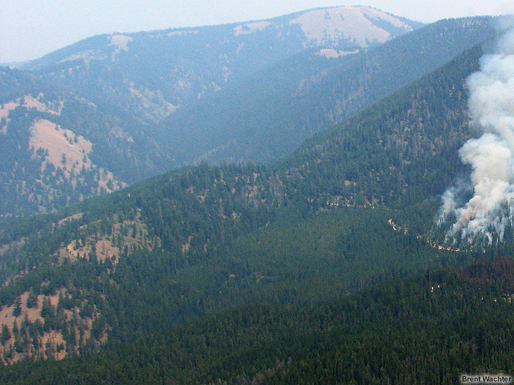
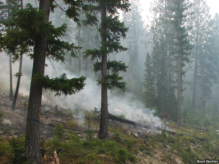
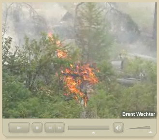
Although this fire was active on other days (it eventually consumed over 27,000 acres), on the 13th of August, fire activity was limited to that of a creeping, smoldering surface fire. The fire spread slowly at the surface, reducing heavy fuels to ash along the way. Isolated torching was also observed, but only occurred within tree stands that were much more continuous and contained heavier surface fuels (jackpots).
Review the following photos and video clip to see what happened.


Video
This video clip shows the fire as it creeps slowly downhill consuming heavy dead and down fuels along the way.
Limiting Factors
Question
What factors prevented this part of the Rombo Mountain wildfire from developing into an active fire? Select the main factors that prevented this from happening. (Choose all that apply from the list below.)
- 100-hr fuel moisture levels were too high
- 1000-hr fuel moisture levels were too high
- Fuels were spaced too widely
- Low Energy Release Component (ERC) values
- Insufficient ladder fuels
- Forest canopies were discontinuous
- Strong mid-level instability
- Terrain lacked steep slopes
- Soil moisture levels were too high
- RH values were too high
- Downslope winds supressed fire spread
- Winds were too light
- Smoke and haze suppressed temperatures
Feedback
The correct answers are 3, 5, 6, 12, and 13. Fuel arrangement and weather were the main limiting factors for our area of interest.
Because this part of the fire burned a previously harvested tree plantation unit, fuels arrangement was discontinuous. Heavy dead and down fuels and ladder fuels were present, but were not plentiful enough to support active fire behavior at the surface or within the canopies.
Smoke and haze from the intense fires in Idaho also suppressed fire activity. The smoke blocked sunlight, which reduced surface temperatures and limited convective mixing. (See the RAWS data and satellite images below.)
Beneath the inversion, convectively induced wind flows were limited and terrain-induced wind flows were very light.
Numerous wildfires were burning across Idaho and Montana. The Rombo fire was active on 12 August.
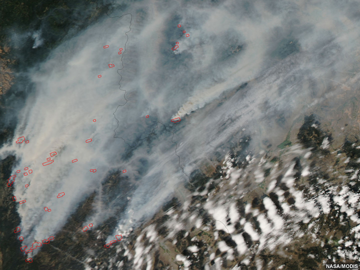
Smoke plumes from Idaho shroud down-wind fires in Montana. The Rombo fire was much less active on this day.
You have now completed this case study.