
Fire Behavior Case Studies
Jungle Wildfire
Return to main page of print version
Introduction
This case study examines a September 2006 fire that occurred in the Absaroka Mountains of south-central Montana.
Review the Fuels, Topography, and Weather sections (below) to learn about the environmental conditions for this fire.
Then, continue to the Fire Behavior section to make a prediction about the types of fire behavior you would expect for the given conditions. Once you have made this prediction, go to the Causal Factors section to answer a summary question about the causal factors for this fire.
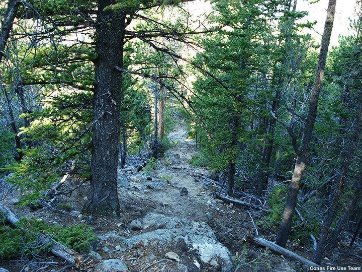
Fuels
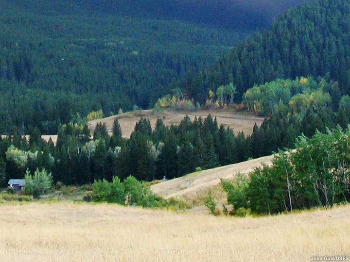
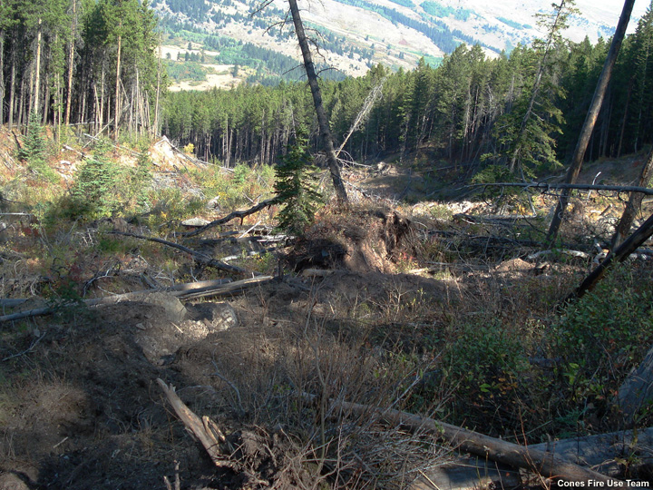
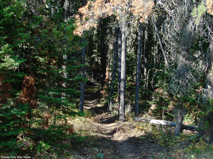
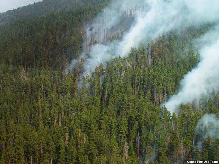
The fire burned in heavily forested areas bordered by open grasslands at lower altitudes and rocky areas in the upper reaches.
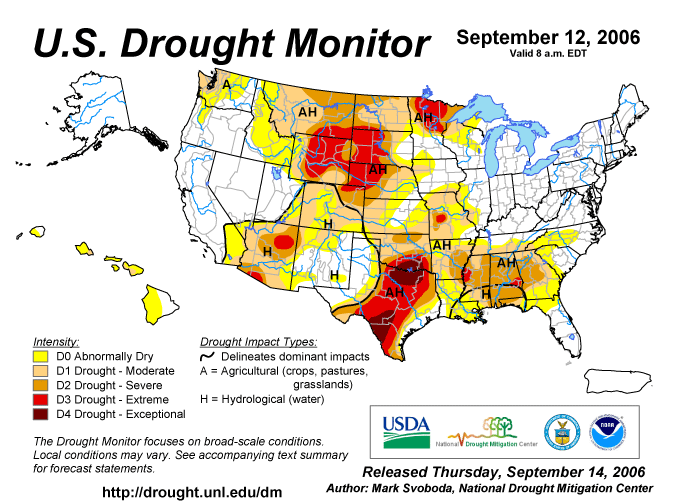
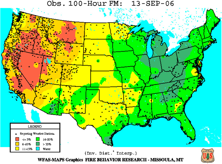
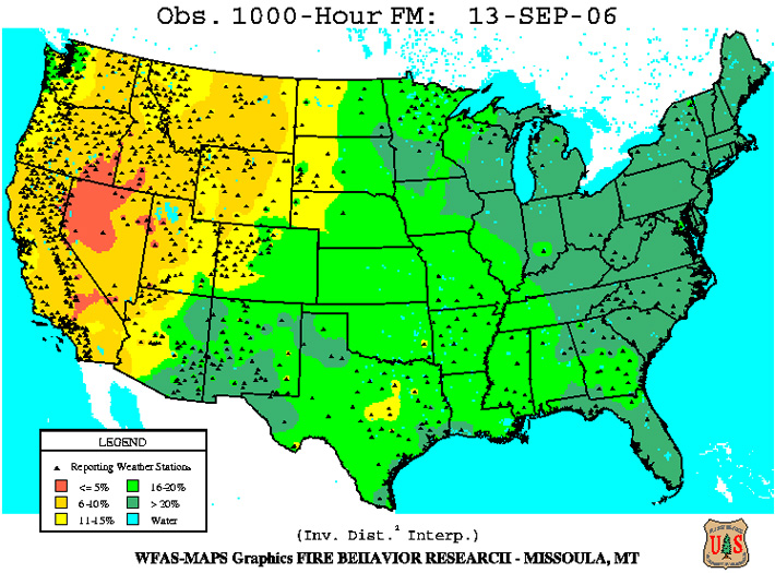
The mixed conifer forests contained plentiful surface litter and heavy dead and down fuels. Canopies were continuous in many parts of the forest and fuel moisture levels were low due to the effects of a pre-existing drought. In the more open areas, woody and herbaceous fuels were curing or fully cured. Grasses were completely cured.
In mid September, as the sun's angle of declination diminishes, daylight hours are reduced and shadows grow longer over the Northern Rockies' rugged landscape. This lowers fuel temperatures and lengthens the duration of higher humidity levels in the dirunal cycle. However, fire danger ratings can remain high at this time of year due to an abundance of well-cured or dormant fuels.
Examine the photos and data products below (you can click them to see enlarged versions) to form an understanding of the fuel situation for this fire. For more information about the data products presented, refer to the Assessing Fire Danger module in the Advanced Fire Weather Forecasters Course.
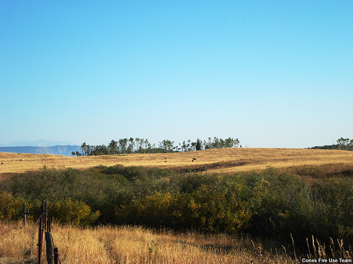
Topography
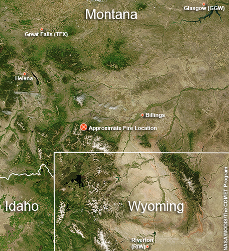
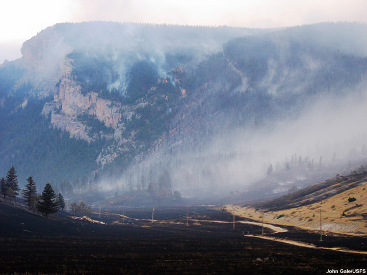
The Jungle wildfire occurred in southern Montana on the northern edge of the Absaroka Mountain Range. The fire consumed forested sections of the West Boulder River canyon, which has a southwest-northeast orientation. Burned areas ranged in altitude from 6200 to 9600 ft. Mountain peaks on either side of this canyon reach above 10,000 ft elevation.
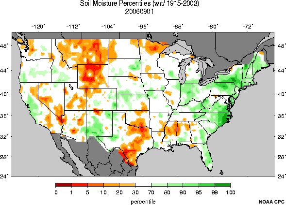
The terrain is varied; many of the upper reaches are steep and inaccessible. Soil moisture levels throughout the area were dry.
Examine the photos below (you can click them to see enlarged versions) to form an understanding of the terrain configuration for this fire.


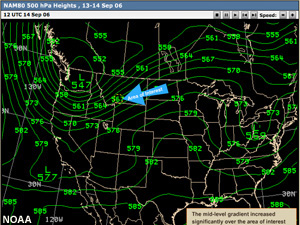
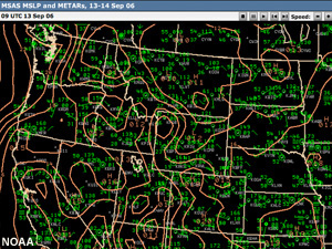
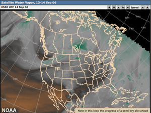
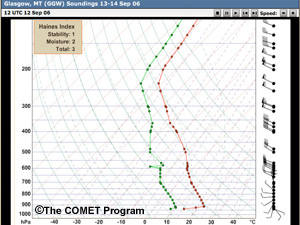
Weather
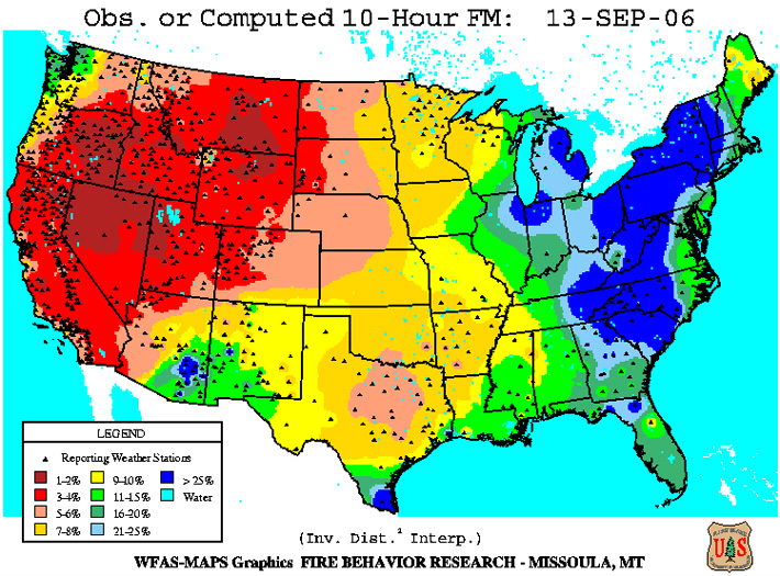
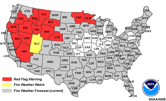
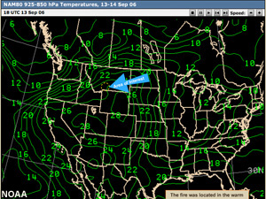
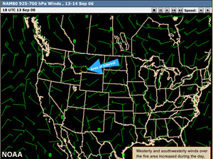
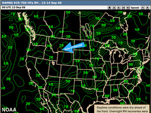
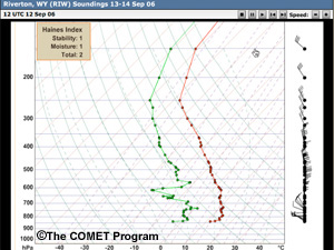
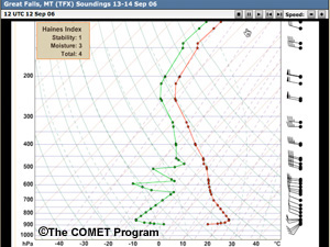
Leading up to the 13th of September, 2006, south-central Montana experienced sunny skies and above-normal temperatures. On the 13th, relative humidity was low, with afternoon readings in the single digits to low teens and overnight recoveries only into the high 20s. Lapse rates were fairly steep and strong winds were observed.
Red Flag Warnings were in effect for much of the Great Basin and Northern Rockies as a cold front was forecast to usher strong and gusty winds in from the northwest.
Examine the data products below (you can click them to see enlarged and looping versions) to form an understanding of the weather context for this fire. Data source locations are indicated on the basemap.


Text Product
SPC Fire Weather Outlook
ZCZC SPCFWDDY1 ALL
FNUS21 KWNS 130908
DAY 1 FIRE WEATHER OUTLOOK
NWS STORM PREDICTION CENTER NORMAN OK
0408 AM CDT WED SEP 13 2006
VALID 131200Z - 141200Z
...CRITICAL FIRE WEATHER AREA FOR A LARGE PORTION OF THE NRN ROCKIES AND THE NRN HIGH PLAINS...
...SYNOPSIS...
A VIGOROUS UPPER SYSTEM WILL MOVE INTO THE PAC NW THROUGH TONIGHT. AHEAD OF THIS SYSTEM...AN AREA OF SFC LOW PRESSURE
WILL DEEPEN OVER THE NRN HIGH PLAINS. BOTH OF THESE FEATURES WILL LEAD TO A BROAD AREA OF MODERATE WSW WINDS OVER
MUCH OF THE NRN ROCKIES/NRN PLAINS. COMBINED WITH LOW RH READINGS...CRITICAL FIRE WEATHER CONDITIONS ARE ANTICIPATED
OVER THIS REGION.
...CRITICAL FIRE WEATHER AREA - MUCH OF ID/MT/WY AND PORTIONS OF WRN ND/SD...
PRIMARY CONDITIONS: SUSTAINED WSWLY WINDS FROM 20-25 MPH WITH GUSTS OVER 35 MPH...MIN RH READINGS FROM 10-15 PERCENT
AHEAD OF A STRONG UPPER TROUGH...AN AREA OF SFC LOW PRESSURE WILL DEEPEN OVER CENTRAL/ERN MT TODAY/TONIGHT. ALONG
WITH INCREASING MID LEVEL WIND FIELDS...WSWLY SFC WINDS FROM 20-25 MPH WITH GUSTS OVER 35 MPH WILL DEVELOP AHEAD
OF A COLD FRONT THAT WILL BE LOCATED FROM NWRN MT INTO ECENTRAL ORE BY THE LATE AFTERNOON HRS. BEHIND THE COLD FRONT
SIMILAR WIND SPEEDS WILL BE FOUND...BUT WITH COOLER TEMPERATURES...MIN RH READINGS WILL AVERAGE FROM 20-30 PERCENT.
AHEAD OF THE COLD FRONT...MIN RH READINGS FROM 10-15 PERCENT WILL DEVELOP DURING THE AFTERNOON LEADING TO A CRITICAL
FIRE WEATHER THREAT. OVER WRN SD/ND AND FAR ERN MT WINDS WILL BE SLY FROM 20-30 MPH ALONG WITH SIMILARLY LOW RH READINGS.
..CROSBIE.. 09/13/2006
NOAA/NWS
Fire Behavior
Question
What kind of fire behavior do you think resulted from the combination of fuels, topography, and weather conditions you have seen for this event?
- Extreme fire behavior characterized by large plumes with erratic long-range spotting
- Extreme fire behavior resulting from strong winds and very rapid fire spread
- Extreme fire behavior resulting both from large plumes and very strong winds
Feedback
Choice three is the best answer. This fire exhibited a range of extreme behaviors including crown runs of long duration, rapid spread, long-range spotting, and fire vortices.
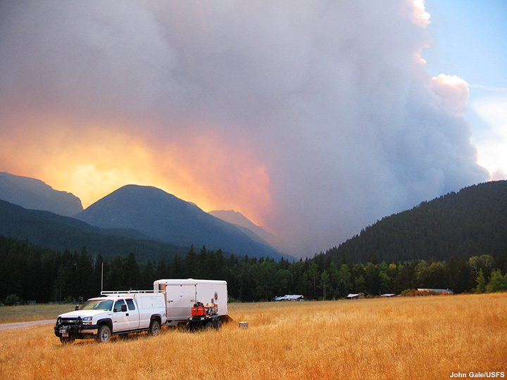
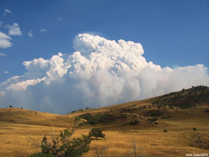
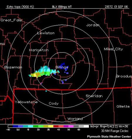
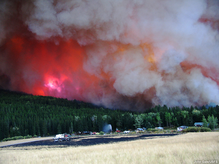
On the afternoon of September 13th, the fire initially generated large plumes reaching heights over 35,000 ft as estimated by the Billings radar 75 miles from the fire zone.
Later, winds helped the fire spread rapidly; it grew from 3173 acres on the 12th to over 27,400 acres by the evening of the 13th, destroying several structures along the way. After burning to the forest edge, the fire raced across grassy uplands to the northeast covering 4 miles in the evening hours before its progress was slowed by fire lines, cooler temperatures, higher RH levels, light showers, and calmer winds.
Review the following photos and video clip to see what happened.

Video Clips
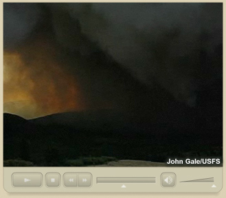
This video clip, recorded by John Gale at 4:12 PM on the afternoon of September 13 2006, shows the Jungle fire approaching the mouth of West Boulder River Canyon. Note that the hillside to the right of the main fire area is smoke free.
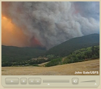
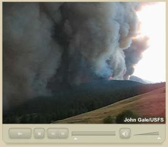
This video clip, recorded by John Gale shortly after the preceding video, illustrates the fire's rapid spread. Although the video was shot during the mid-afternoon, smoke has turned the sky black. Look for the spot fires developing to the right of the main smoke column.
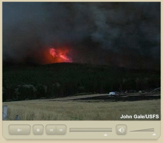
A short while later, the fire is advancing down the slope to the right of the main fire column. Large flames can be observed as the fire's roar can now be heard.
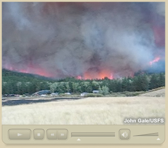
A large and very active flaming front approaches structures along the forest's edge.
This final clip gives you a sense of the fire's fury. Listen to its roar and look for the major convective flare-up and fire whirl to the left near the end of the clip.
Limiting Factors
Question
Why did extreme fire behavior occur with the Jungle Wildfire? Select the main factors that allowed this to happen. (Choose all that apply from the list below.)
- Low fuel moisture levels
- Abundant ladder fuels
- Dense, compact forest vegetation
- Continuous and dry canopy
- Plentiful dry dead adn down fuels
- Exceptional drought conditions
- Upslope winds aligned with chimney formations
- Low soil moisture levels
- Warm temperatures; low RH levels
- Northerly winds behind the cold front
- Southwesterly winds ahead of the cold front
- Strong instability
Feedback
The correct answers are 1, 2, 3, 4, 5, 8, 9, 11, and 12. Fuels, topography, and weather factors were all favorable for extreme fire behavior. The forest contained densely arranged heavy fuels with low fuel moiture levels due to an ongoing drought. Finer fuels such as shrubs and grasses were also curing or well-cured. An early freeze in September can enhance curing of these fuels, and such was likely the case with this fire. Soil moisture levels were also low.
Although the fire progression was downslope, it was still rapid because the southwest-northeast alignment of the canyon was matched by strong gusty southwesterly winds ahead of the front. Also, in the warm sector ahead of the front, humidities were very low and temperatures warm.
Strong instability supported development of a vigorous plume as well as fire vortices and whirls. These instability-driven behaviors resulted in erratic, rapid, and long-range spotting.
You have now completed this case study.